

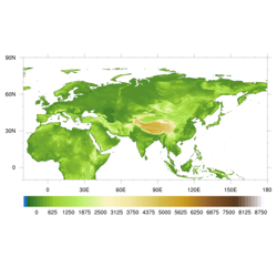
数据来源于美国地质勘探局(USGS)开发的30秒全球高程数据集,于1996年完成。从NCAR和UCAR联合的数据下载中心(https://rda.ucar.edu/datasets/ds758.0/)下载了泛第三极区域的数据,并通过数据中心重新分发。GTOPO30在分发时将全球分为33个区块,采样间隔为30弧秒, 即0.008333333333333度,坐标参考为WGS84,其值为垂直方向高出海平面的距离,即海拔,单位为m,海拔范围-407到8752,这里不包含海洋深度信息,负值为大陆架的海拔;海洋处标记为-9999,海岸线以上大陆海拔至少为1;小于1平方千米的岛不考虑。详细说明信息请见说明文档。 为了便于用户使用方便,在分块数据的基础上,将-10S-90N,20W-180E内10个区块进行拼接,没有经过任何重采样处理。本数据文件为DEM_ptpe_Gtopo30.nc
2140 211 2019-01-15
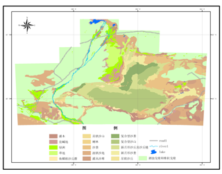
该数据来源于中科院沙漠研究所(现中科院寒旱所)编制的巴丹吉林1:50万风沙地貌数据集。 数据集主要包括:dimao(地貌),height(沙丘高度),lake(湖泊),lvzhou(绿洲),river(河流),road(道路)。
12046 211 2013-07-20

该数据源是1991-1996年,俄罗斯出版1:250的《Geocryological Map of Russia and Neighbouring Republics》系列图,该图采用俄语标注,共16幅。1998年,Zaitsev等将其翻译为英文。这次数字化,将选择其中的7个主题进行数字化,分别为:1)Distribution of frozen and unfrozen ground,2)Mean annual temperature of unfrozen ground at the depth of zero annual amplitude” might be awkward as we do not know where is the depth of zero amplitude, and lack data, generally. 3)Thickness of permafrost,4)Depth from the surface and thickness of relict permafrost, 5)Distribution of permafrost containing cryopegs, 6)Thickness of permafrost containing cryopegs, 7)Distribution of permafrost with depth。 1、该数据包括两个矢量图层:(1)冻土分布层(permofrostpermafrost distribution)(2)冻土温度层(permafrost_temperature)(3)冻土厚度图(permafrost thickness)(4)冻土形成条件(permafrost formation conditions)(5)纠正图像(Correction Image) 2.冻土层分布图包括以下几个字段:AREA,PERIMETER,FROZEN_,FROZEN_ID:POLY_,POLY_,RINGS_OK,RINGS_NOK,A,冻土层:FROZEN_SOI,温度。冻土层和FROZEN_SOI是冻土类型的中英文表示。 4、冻土层属性: Frozen-Soil 冻土层 温度水域 Continuous Predominantly unfrozen 连续大片非冻土 1-5 Continuous permafrost 连续多年冻土 -3- -5 Continuous unfrozen ground 连续非冻土 4-6 Discontinuous permafrost 不连续多年冻土 0.5- -2 Predominantly continuous permafrost 大片连续多年冻土 -1- -3 Predominantly unfrozen ground 大片非冻土 1-3 5、投影信息: PROJCS["Asia_North_Equidistant_Conic", GEOGCS["GCS_North_American_1927", DATUM["North_American_Datum_1927", SPHEROID["Clarke_1866",6378206.4,294.9786982]], PRIMEM["Greenwich",0.0], UNIT["Degree",0.0174532925199433]], PROJECTION["Equidistant_Conic"], PARAMETER["False_Easting",0.0], PARAMETER["False_Northing",0.0], PARAMETER["longitude_of_center",100.0], PARAMETER["Standard_Parallel_1",15.0], PARAMETER["Standard_Parallel_2",58.3], PARAMETER["latitude_of_center",60.0], UNIT["Meter",1.0]]
12109 165 2011-03-13
©
中国科学院青藏高原研究所
2012 -
|
联系我们
|
使用条款和免责申明
| 京ICP备05002818号-11
|
 京公网安备11010502040845号
 技术支持:中国科学院十三五信息化专项科学大数据工程项目
 2019-01-15
 2140
 1

